Benefits Of Rivers Conservation And Flood Management
Until the US Army Corps of Engineers (USACE) introduced flood remediation projects in 1968, Chartiers Creek flooded, on average, every year since 1912 when formal records were initiated. The first serious flood of record was that of September1912. According to the USACE, it was the highest known flood for Chartiers Creek prior to that time. However, the highest flood of record occurred in August 1956. This flood resulted in the loss of 40 lives and left hundreds. There was substantial loss of property, crops and livestock. Bridges were washed away and manufacturing facilities were damaged. The Cannonsburg business district was completely inundated. As a result of these major floods and several lesser floods, the USACE introduced flood remediation projects in 1968.
Effective flood management and related land use planning provides significant economic benefits and cost savings. There are a variety of human activities that impact hydrology and intensify flood damages. Generally, these include:
There also a number of management activities that can mitigate the impacts of flooding and provide economic benefits. These include:
Benefits of rivers conservation can be shown by reviewing the costs of flooding. The US Army Corps of Engineers (USACE) has proposed a flood control project in a small community in the watershed. Houston, PA, is a small borough in the upper watershed along Chartiers Creek. It has a population of 1600 with 679 housing. The USACE estimated that:
Economical solutions to flood risks include:
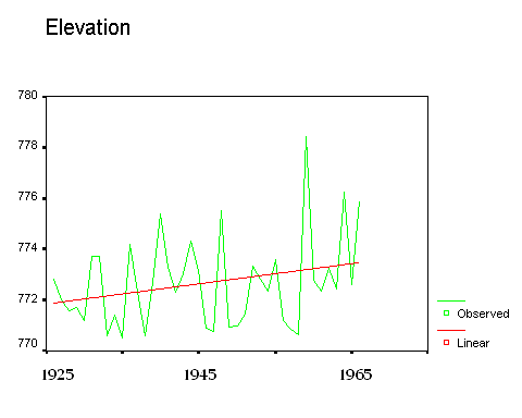
Figure 1 below shows the increase over time in flood elevations along the Chartiers Creek. This was a period of development in the watershed and the flooding history illustrates the impact of landscape development on flooding.

Flood Elevations for Floods of Record at The Carnegie Gauge: 1925-1965
(source: US Army Corps of Engineers)
Figure 1
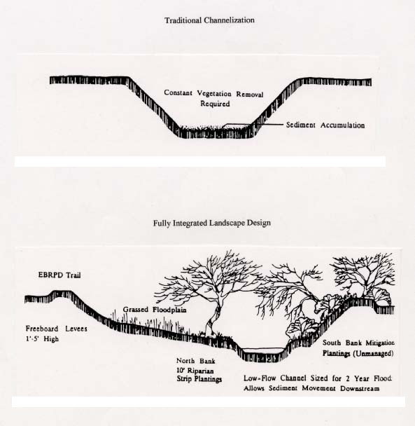
Management of streams for flood control involves the proper geometric configuration and vegetation control. Figure 2 below illustrates both traditional stream channelization methods designed to speed the movement of waters out of a watershed, and landscape designs for increasing the capacity of the stream and riparian buffers to contain large volumes of water.

Traditional and Fully Integrated Riparian Landscape Design for Flood Control
(source: Riley, Restoring Streams in Cities, 1998)
Figure 2
An advantage of more extensive use of landscape and riparian features to manage heavy rainfall events is potential increases in property values associated with flooding mitigation features. For example, views of wetlands and natural streams enhance property values. Rinehart and Pompe (1999) find that views of ponds added up to 12% to the values of condominium properties in Massachusetts. A 130 acre development in Highland Park, IL, included a 17 acre constructed wetlands for water management, and lots adjacent to the wetlands sold for a 10% premium (Tourbier and Westmacott, 1992). A similar 4 acre wetlands in a Boulder, CO, residential development resulted in a 30% premium for lots with a wetlands view. A 14 acre runoff detention pond in a residential development in Alexandria, VA, was developed to include a walking trail, and lots fronting the pond garnered a 6% premium (EPA, 1995).
References
EPA, 1995. Economic Benefits of Runoff Controls, Office of Wetlands, Oceans and Watersheds, http://www.epa.gov/owow/nps/runoff.html
Riley, Ann L, 1998. Restoring Streams in Cities: A Guide for Planners, Policymakers and Citizens, (Island Press, Washington, DC)
Rinehart, J.R. and J.J. Pompe, 1999. "Estimating the Effect of a View on Undeveloped Property Values," Appraisal Journal, vol. 67, no. 1: 57-61.
Tourbier, J.T. and R. Westmacott, 1992. "Lakes and Ponds," 2nd edition, The Urban Land Insitute, Washington, DC