Storms and Southerlies
July 17, 2010
Finding days to sail this summer has been difficult. It seems as if thunderstorms are forecast for every day. The forecast for the coming week is no exception:
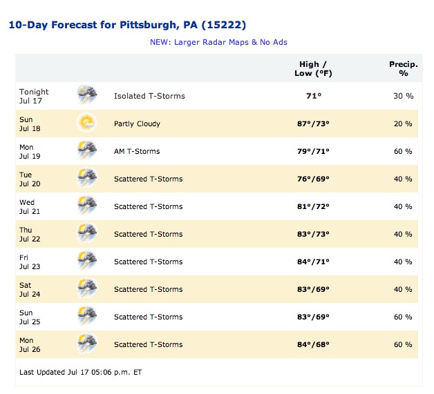
With forecasts like that routine, it is hard not to get intimidated. The forecast for today was no less worrisome. Storms again, but at least not until 5pm. Here's how it looked just before I set off to go sailing.
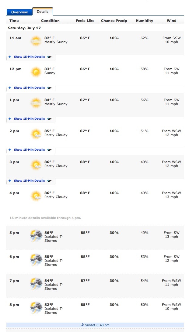
It seemed that these were good winds in the afternoon and it was worth putting the boat in the water for them. If a storm blew up, I imagined I'd just dock somewhere, get well away from the lightning rod that doubles as a mast and wait it out. With mid 80's temperatures, there's no need to fear getting chilled.
On my ride over, I paused as is my habit at the pier at the Del Monte building to measure the wind at the Point. It was much less than the 11 mph expected for that moment (around 11:30am). The wind was blowing lazily in the 3-6 mph range. Moments after I continued my ride, it picked up. I stopped and measured a more comforting 12 mph.
In the end, I had made the right call. The winds for the first hour of my sailing (12-1pm) were much less than the 11mph forecast. I was getting winds I'd estimate around 3-5 mph and long periods of calm with little or no wind. That calm made the first hour hot and unpleasant. I sweated in the mid 80s heat and my progress upstream was maddenly slow.
The winds picked after that, but there were no sustained winds of 11-12 mph. They were much lesser winds with occasional gusts that had me releasing the mainsheet to avoid tipping. There was no storm. Around 5pm, perhaps an hour after I'd come out of the water, I did notice some ominous storm clouds on the western horizon. (The photo of the valley below was taken then.) But nothing stormy materialized. While getting caught in a thunderstorm on the river is a Very Bad Thing, I've resolved that I'm not going to let forecasts of storms "spook" me.


For tomorrow we have organized a sailing picnic with friends at Moraine State Park. The forecast storm can be damned! (Later news--at the last moment the forecast was revised to predict no storms; and there was none. We had a great day sailing!)
What was most noteworthy about this sail was that I finally affirmed what I had always suspected about how Southerly winds are funneled onto the rivers. The Sourthern shore of the rivers are shielded by high hills. There is a gap in the hils, a little valley, roughly where the West End Bridge crosses the Ohio.
Southerly winds, I had always expected, would be funneled through that gap and dumped at that spot on the river, from which they would spread out. I'm now sure that happens. My sailing today showed the winds to blow across the river from the south in line with the valley and to spread out up and downstream from there, blowing away from this spot.
The first clue that this might be happening today came when I arrived at the Newport Marina downstream of the West End Bridge. While Southwesterly winds were forecast, the wind was blowing at the marina from the Southeast. That means it blew with the current and not against it. That is bad, since a wind that blows with the current makes beating the current harder, as explained here. Fortunately, the current on the Ohio River was low--just 10,000 cubic feet per second--and I could see virtually no motion of debris with the current in the river. There wasn't much current to beat.
I sailed up the river, docking at Heinz Field. There my friend Jim joined me. He'd wanted to try sailing on the river and this was a good day to try it. Here are some photos of the beached boat taken while I waited for him.
We sailed about a bit at the point and then went a little up the Allegheny. We sailed back to Heinz Field, where I dropped him off. Then I sailed back to the Newport Marina.
All in all, this was one of the hardest of wind conditions for sailing. The winds were not steady, but moved rapidly from calm to gusts. So I kept my hand on the mainsheet, ready to release it before the gust tipped us into the water. Worse, the wind direction kept changing. I can usually use the various flags on the shore to determine the wind direction. But today it was quite possible for us to have an Easterly wind at the boat, while watching the flags blow in a wind from the West.
At one memorable moment, we were approaching the Fort Duquesne Bridge from downstream, when the wind abruptly shifted from West to East. The boat lurched and spilled me into the water. We didn't tip, I'm guessing, because the mainsheet wasn't cleated and because Jim's weight on the deck kept things level. I hauled myself up onto the deck, water pouring off me. It was a little rattling to be hurled so suddenly into the water.

"You OK?" Jim asked. I didn't want to admit that I'd been rattled, so I assured him that I was fine and set about getting underway immediately. And I was fine. I was a little surprized how untroubled I was at being hurled into the water so suddenly. I was now soaking wet too, but it was actually quite refreshing. It was very hot and the wind blowing on my wet shirt was just delightful.
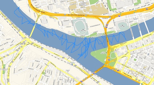
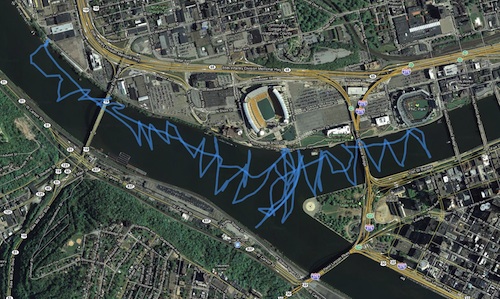
Back to the story of the Southerly winds... Here is the GPS track of the sail.
The voyage starts in the upper left corner. The lower track is the initial track taken to sail upstream to the point. Notice how, after an easy start, it zigzags as I tack into a wind that comes from the East. As I pass the West End Bridge, the wind is coming from the south and my tacks turn towards the South. Finally once I've passed the bridge, the winds are blowing from the West along the river and I sail in a straight line with the wind behind me.
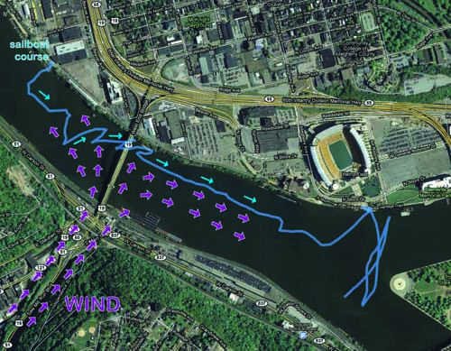
I've extracted this part of the track below and added the direction of the wind.
This track now makes a little clearer why the stretch of the Ohio River in front of the Newport Marina can be difficult to sail. If the winds are blowing from the South West, we might expect winds to blow roughly from the West in that stretch of the river. However we can now see that these Westerly winds will meet winds funneled from the valley, blowing in the opposite direction--and quite possibly do it exactly where I put into the water. It is hard to say what will result. Perhaps we will have periods of calm as the winds cancel, or eddies blowing unpredictably. Either way, it will be hard sailing.
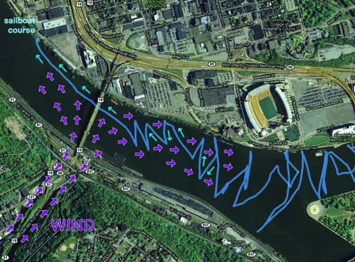
The geometry is reversed on the return. In front of Heinz Field and the Science Center, I tack back and forth into a Westerly wind, tacking in symmetrical zigzag across the river. As I near the West End Bridge, the direction of the zigzags changes in response to a wind that blows more from the South. Once I reach the Bridge, the wind is blowing from the East with the current. I have an easy sail back to the marina with the wind behind me.
Here's the relevant part of the track:
This was difficult sailing. In retrospect with the help of a map plotting the GPS track, there is a simple geometric clarity to it all. But it is not so when you are sitting on the deck in the river. All I knew is that the winds seemed to change direction continuously. I was constantly thinking and rethinking. The sudden gusts also made tacking hard. At one point, as I neared the submarine at the Science Center, I could not make the tack and ended up sailing between the submarine and Explorer boat, just clearing a mooring line from the submarine.
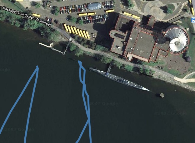
So the bad news is that Southerly winds make for erratic winds on the river. But there is a good side. Once the Ohio River and Point is cleared, these winds blow more cleanly up the Allegheny. We found it relatively easier going and more predictable to sail past the Duqesne Bridge up the Allegheny, as the track shows.
All in all it was a good day. It was quite rewarding finally to get clear evidence of what I always thought Southerly winds did on the rivers.
John D. Norton
Back to main
