Save the Fastest for Last
August 16, 2011
Launching the little Hobie Bravo has now become quite uncomplicated. If the winds look favorable, I now find that I can make an early exit from my office in the early afternoon and still have a good sail. Thank you daylight saving!
Today, the winds looked very promising. For the time I'd be in the water (3:30-6:20pm) the forecast was calling for 7-9 mph winds from the NNW. What I found reported when I reached the river was a little less than that. It was roughly 6-7 mph winds but from the NW. That shift from NNW to NW was enough to align the winds much better with the river course.
(Update: the actual weather records show the winds shifting between North and WNW during the sail and varying from 3 to 8 mph.)
My expectation was that these NW winds would run me reliably down the Ohio River to the Point. Then they would be erratic on the Allegheny River, where they would blow round obstructions on its northern bank; and they would be strong and steady on the Mon River.
(River currents, I should add, were too low to consider: Allegheny, Mon, Ohio, Yough.)
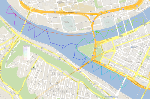
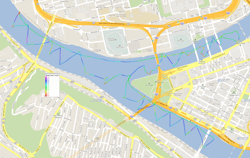
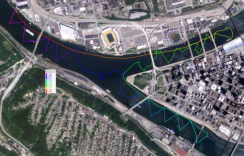
I made it to the Point on a run with the wind at my back up the Ohio in about 15 minutes; and then continued on a run up the Allegheny for another 20 minutes to the Convention Center. There I turned and began the slow tack back into the wind. The gps tracks below show clearly how erratic the wind was. There were lots of periods of dead calm. They are the little red spots in the speed-coded track. The contorted track shows me chasing the wind as it changed direction from place to place. It took 45 slow minutes, that included me delaying progress to keep clear of the Duchess riverboat as it traveled upstream and then back downstream.
This was what I expected. I wouldn't have chosen to sail on the Allegheny rather than the Mon with these winds. However I am using these sails to map out the winds at the river surfaces. I wanted to test if a North West wind really is difficult to sail with on the Allegheny. Confirmed. It is! But it is not unbeatable.
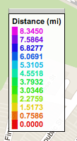
Here are the gps plots. The first and third have a new feature: the distance covered is color coded and the plot reveals that the entire sail had my boat covering 8.34 miles.
Once I was back at the Point, I turned down the Mon, where the winds were stronger and steadier, as expected. I was saving the fastest for last.
It was a 20 minute run down to just past the Smithfield St. Bridge. Tacking back into the winds was uncommonly fast. My two to one rule says I should expect to spend twice as long tacking back into the wind. This time it took only 25 minutes. That I attribute to a sudden strengthening of the wind.
Once I regained the Point, however, the wind pattern changed. It was still a 6-7 mph wind from the North West--but only when it blew. I'd speed along for a few happy minutes. Then the wind would die completely for a few minutes, even though I was in clear water for North West winds. Then It would pick up again. I have no idea why that was happening. (Update: the actual weather records shows a switch to WNW winds around this time. Perhaps that was enough to have the ridge on the Southern shore of the Ohio and Mon blocking the wind.) The final leg from the Point to the marina took 40 minutes.
Here are some photos taken on the way.
Just when I had the mast up and the boat rigged, a barge rumbled past.
The view at some places on the shore is still old Pittsburgh. This is just upstream of the dock, passed on the way to the Point.
Here's the Explorer sailing downstream.
I've just turned up the Mon and am passing under the Fort Pitt Bridge, when I have this view under the roadway.
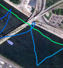
On the return, I missed a tack trying to squeeze through the smaller arch on the downtown side of the bridge. To escape, I had to steer in behind the pillar you see on the left, making a little loop in the gps track:
There was a sound stage set up at Station Square. At apparently random moments, the music would switch on and boom across the water.
In this stretch of the Mon, you feel very close to the buildings of downtown.
Here's the Smithfield Street Bridge, laden with commuters on their way home.
Rounding the Point:
Looking back at the Point, one can sense how big the river feels from the deck of a small boat.
Home--back at the marina and ready to unrig:
John D. Norton
Back to main
