Into the Wind
August 9, 2016
Today the winds are forecast to blow from the Southeast. Here was the forecast I found this morning before setting out:
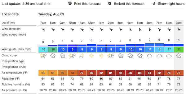
I am usually wary of Southeasterly winds.
First, they blow along the Mon and Ohio Rivers past the Newport Marina with the current. That makes it harder to beat the beat the current flowing from the Point as I try to sail up to the Point, as I explained here.
However today I was less concerned. The flows on the rivers have been low for a while. I looked only at the Ohio River, since that is the one at the Newport Marina. It was down at 6,000 cubic feet per second:
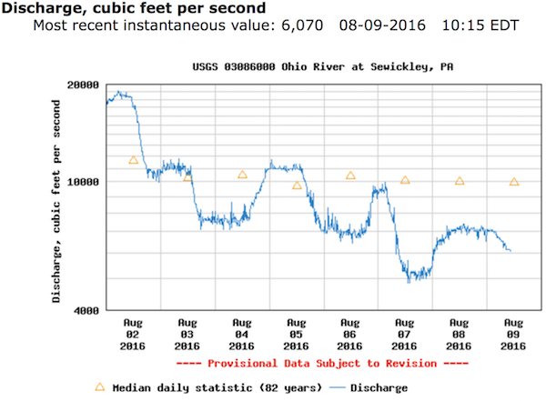
I estimate that to correspond to about 0.13 miles per hour. As long as there is wind, that small amount of current should not be hard to beat
Second, my experience has been that Southeasterly winds are transient and hard to predict. The forecast can assure us of this or that wind from the Southeast, but, by the time you are in the water, the wind can come from any and even many directions.
Again, I set these worries aside since the report of actual conditions so far indicated that the winds were steady and as forecast.
In addition, I'd been watching the forecasts for the next ten days.
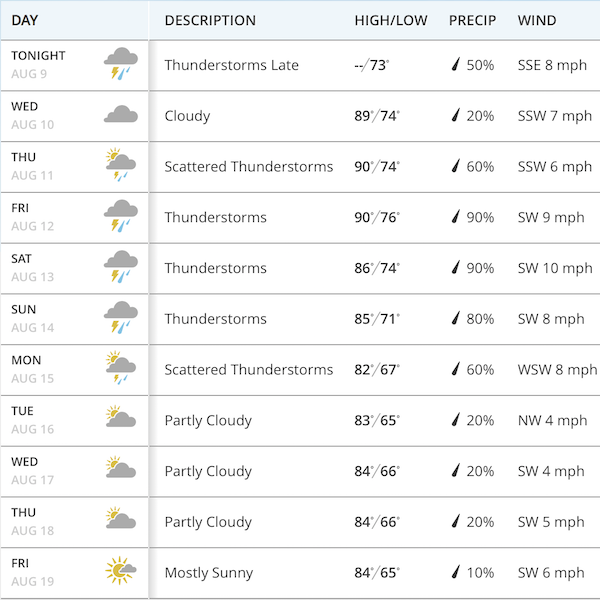
They are predicting mostly Southwest and South-southwesterly winds. They are the worst for sailing around the Point, since they are blocked by the high ridges on the Southwest banks of the Mon and Ohio Rivers.
So it was now or there would be no sailing for another week. I had come to the marina over the weekend and, with some four-legged help, had hauled the boat off its trailer and cleaned it up, ready for the water. I was ready to go and sail.
The die was cast. I collected my sailing gear, emailed my apologies to the office and set out on my bicycle. When I passed the point, I was pleased to see that the plume of the fountain was indicating just the sort of Southwesterly winds I wanted:
At the marina, I walked to the end of dock to take a wind speed measurement. I could see the wind on the water blowing roughly from the Point. The gauge first leapt up to 10 mph, but then settled down to a calmer 4 mph.
I soon had the boat rigged and in the water.
I put into the water at 12:40pm. I could see a steady breeze on the water in the moving ripples that you see in the photo above. The boat set off well and I began the arduous task of tacking to and fro into the wind.
The winds were mostly steady, giving me occasional fast spurts and dropping from time to time. I could see as I tacked back and forth that I wasn't making as much distance as I'd like. Each time I'd return to a bank, I'd be only a little advanced.
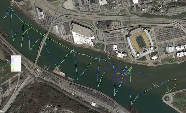
Here's the GPS track of the sail:
It is time for a little arithmetic. In better breezes, I was making 3-4 mph. However that was not in the direction of the Point. I'm tacking across the river. If I am tacking at 45 degrees, then only 70% of that speed moves me towards the Point. If I am tacking at 60 degrees, then only half that moves me towards the point. So I am making 1.5-2 mph towards the Point. Now add in occasional moments of calm. That drops my average to, perhaps,1 mph.
Earlier I had dismissed a current of 0.13 mph as negligible. But if that current is constantly moving me away from the Point, it will make a difference. If the situation were reversed and I was tacking with the current, then I'd add that 0.13mph to my speed, not subtract it. The difference would be 0.26 mph.
All in all, in took me an hour of laborious tacking to make it to the Point. That gave me plenty of time to do my mental arithmetic!
I arrived at the Point around 1:40 pm. By this time, the winds had turned almost completed to the South. As soon as I passed the Point, it blocked the wind and I was stuck in a wind shadow.
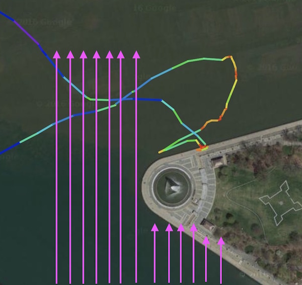
You can see its effects. Before I pass the Point, my GPS track is color coded blue and green, indicating 3-4 mph. Once I pass it, there's lots of slower yellow and even red, indicating no motion at all.
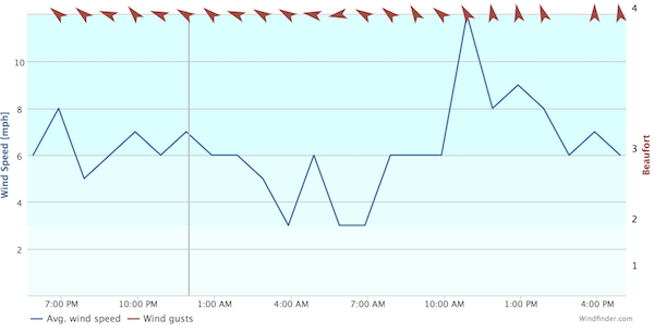
Here's a graph of the actual conditions:
So much for the reliability of the forecast. The Southeasterly wind had turned pretty much all the way to the South. Had it gone a little more Westward, it would have been blocked completely by the ridges on the Western bank. On a happier note, the wind speed had remained steady in the predicted range.
I docked briefly at the Point. It was a chance to stretch my legs, drink some water and nibble the provisions I'd brought.
Looking towards the Point, you can see the wind shadow in the water in the photo below:
The water is glassy, indicating no wind, close to me. Once we look past the point, the water is rippled, indicating wind.
I set off again at 2pm. The winds were blowing steadily from the South now. I took the opportunity to sail back and forth across the wind a few time. This is my first time out sailing this season. It takes a little while to recover my sea legs, which I need to be able to maneuver the boat fluidly and easily. I had my sea legs back by then, so it was just fun.
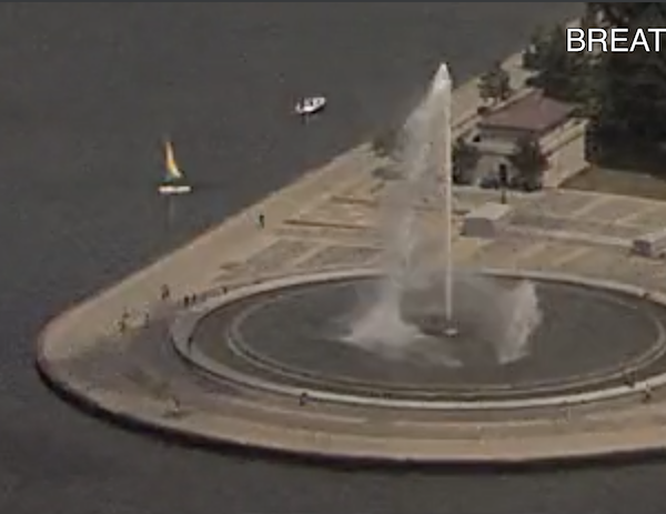
The CMU BreathCam captured me:
A few Ducky boats powered past.
I had to pull over and sail in a little circle when a large riverboat set its course a little too close to me.
Now I'd been out for over an hour and half. Sailing a small boat looks lazy, but it is actually quite energetic. You are moving over the deck and holding yourself in awkward positions. I was getting sore, so it was time to head for home. Now the winds and currents were working with me. I let the gentle breezes and slight current carry me home. It took about 15 minutes, from 2:15 to 2:30pm.
Heading for home: the view from the water, right next to the rudder:
Here I am passing under the West End Bridge:
Now pointing my bows directly into the little lagoon where I launch my boat:
After I started the work of hauling the boat out of the water, a large barge powered past:
I haven't perfected the new arrangement for hauling the boat out of the water. It took many tries and much sweat. For next time, I've rearranged the driftwood.
Here are some more photos taken while underway.
When I put into the water, I never know if I will make it to the Point. The West End Bridge is my marker and gateway. If I make it there, I know I will make it all the way.
Here is the approach:
Now I look back in satisfaction at the bridge:
Approaching the Point:
John D. Norton
Back to main
