Dancing with Giants
August 23, 2017
This, my first and possibly, last day of sailing this season on the rivers was memorable. It was the occasion for the first, impromptu meeting of the Downtown Sailing Club. It ended, however, in a delicate dance with two giants of the river.
The afternoon had otherwise been rather uneventful. I had mild winds setting out and enjoyed freshening winds on my sail back to the Newport Marina, about a mile downstream of the point. The winds were blowing from the West. So the only way home was to tack--zig-zag--to and fro across the Ohio River, gradually gaining distance with each tack.
Here's a small part of the larger gps track of the day's sail.
The zig-zag track traces my course on the leftward journey, down the Ohio River, under the West End Bridge, towards the dock in the upper left hand corner. (The other course mapped is my earlier, outward track, sailing up the river towards the Point.) The tacks sweep across the full width of the river, until they don't. Then the zig-zags are confined to a narrow corridor on the Northern part of the river.What changed? As I approached the great arch of the West End Bridge, glancing downstream, I saw a large barge powering up the river. They are the giants of the river and must be avoided. Getting caught under their bows would be a swift end. They have little maneuverability so I must work to avoid them.
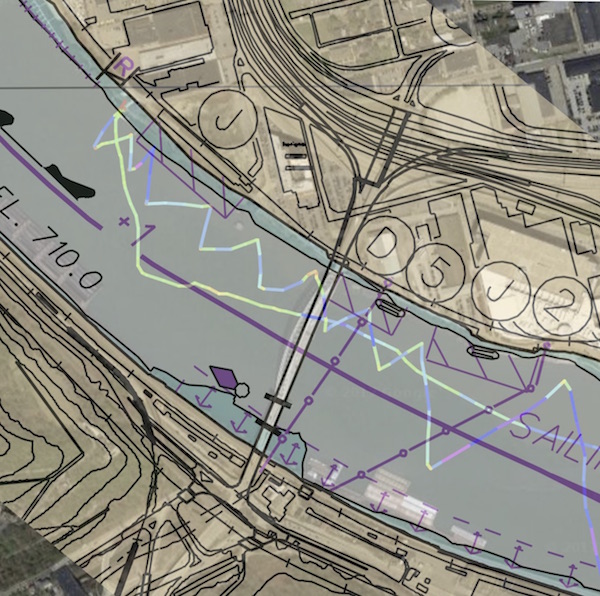
There is only one sure way to avoid being run down by a barge on the river. It's the same strategy for avoiding lightning strikes: don't be where the lightning will strike! In the case of barges, the advice is more useful. Barges navigate a main channel along the river. The channel is well identified by buoys and maps. Here's a fragment of the larger map that covers the portion of the Ohio on which I sailed.

The sailing line is marked in purple. All I had to do was to stay away from it. The river is narrow here, so I do not have much room to navigate. If I had been on another part of the river, I would have sailed over to a bank and docked while the barge passed by. However this section of the river has wooded banks.

If I get too close them, I will get caught up in the weeds and branches. There would be no easy escape. Another possibility was just to "heave to." That is, to do something that stalls the boat in the water. The easiest would be to furl the sail, so I would sit essentially dead in the water. On another day, that would be possible. But the winds had freshened and, I'm guessing, were running in the 6-10 mph range. If I furled the sail, these winds would blow me upstream to who knows where. More likely than not, I'd end up in the weeds on the banks.
So there seemed no choice but to stay on the river and keep sailing, avoiding the barge on one side and the river bank on the other. I could also have turned back and sailed on a run to safer waters, where the banks were benign. However it seemed unnecessary since I had a definite corridor in which to sail.
So I sailed on, now keeping to the tight zig-zags you see on the track. After passing under the West End Bridge, here's my view of the barge.
It was about this time that I looked upstream and noticed something I had not considered in taking the decision to proceed. There was a SECOND barge coming downstream towards me, from the other direction. Would there be enough space on the river for all three of us?
I sailed on. Here I took a moment to take photo of the first barge as I approached it on an outward tack. I'm now safely past its bows, so the only real danger was the other barge approaching from the left of the picture.
At this point, there seemed to be nothing to do other than sail on, keeping within my narrow corridor. As it happened, the second barge seemed to slow down and the two barges passed each other upstream of my location. The second barge was heading to dock at a point on the river opposite the marina where I keep my boat. Here it is docked:
The tugboat (or is it "pushboat"?) that moved the barge disengaged and came round to position the barge:
It had been an energetic close to the day's sailing. I had to make many tight tacks, without missing any. If I missed the turn and had to keep sailing in the original direction, I'd end up sailing into the weeds on the bank, or perhaps meet something worse on the other side.
I overlaid my gps track with the map above to see how well I navigated. It looks like this:

My zig-zags kept exactly in the safe corridor. It is not so easy judge your position on the river, so I'll admit to being a little smug. Here is the view over my bows on my last tack into the marina at the end of the sail.
You might think that I found this a harrowing experience. On the contrary, this is why I love sailing on the rivers! It's not just pointing the bows in one direction and sailing on and on and on. That gets to be tedious. Every sail on the rivers is a little challenge. Where on the river in the best wind? How do I use it? How can I round the pylons on this bridge? It's never dull. And this time it was, how do I sail on with two barges approaching from opposite sides?
----oOo----
So ended a late start to my sailing on the rivers this summer. It was late for several reasons. This summer once again, I have been traveling a lot. Then, in July, there were unusually high currents on the rivers. In past years, the Allegheny River has been responsible for higher flows, when they happen. This year it was the Mon and Yough. They had flows in July and early August over ten times the normal flow. Here's a record for this time:
The combined flow from the Allegheny, Mon and Yough on the Ohio River:

The yellow triangles show the 83 year medians. They run in the 10-20,000 cubic feet per second range. The peak flows recorded, however, were in the mid 100,000 cubic feet per second.
Here's the flow on the Mon for the same period. It is the source of much of this high, Ohio River flow:

Once the river currents had subsided, I had to wait for a day with steady winds that would blow along the Ohio River, so I can sail up it to the Point. That means, ideally, Northwesterly winds. These conditions finally came together today, August 23.
Here are the currents on the Ohio for the day, just before sailing:

and here are the flows on the Allegheny, Mon and Yough.
A flow of 15,000 cubic feet per second on the Ohio River translates into about 0.33 mph. That is a flow I can readily beat with winds blowing against the current. The predictions were that I would have those winds. The forecast called for West North West winds of 8 mph.
Perfect! The speed is just where I like it. Not too strong or weak. The direction blows straight up the Ohio River to the Point. The CMU Breathecam also showed winds blowing from the West North West in the plume of the fountain at the Point:

I had appointments earlier in the day, so I couldn't bicycle over the to marina until around 3 o'clock. There I found my sailboat on its trailer, where it hibernated for the winter.
I soon had it off the trailer and had cleaned off the winter dirt and debris. Here it is at the water's end with the mast up and ready to go.
I pile up driftwood around the rocky ledge at the waters edge, so I can slide the boat into the water without damaging it.
At the end of the dock and ready to sail:
A train thundered past, at that moment, on the opposite bank:
I set off into the Ohio River at 3:45pm. There was a gentle and steady wind blowing upstream towards the point. So the sailing was easy on a run, with the wind on my stern. I arrived at the point 20 minutes later at around 4:05pm. Then I turned my bows up the Allegheny to where I'd seen Rob and Olga Noll sailing their mini-fish during my bicycle ride over to the marina. I docked at the Ninth Street Bridge at 4:20pm. Rob and Olga greeted me and we held our first downtown sailing club meeting.
I set off again at 4:45pm and found that the winds had freshened nicely. I could maintain a pleasing 5 mph, sometimes even a little faster, while tacking into the wind. I passed the Point at 5:10pm and headed down the Ohio, where I met the giants.
Here's the full gps track on the day's sailing:
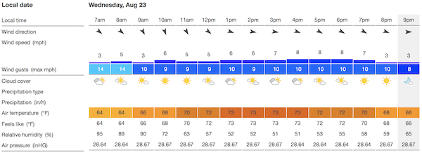
The later weather records showed that the forecast WNW winds did not appear. Instead we had steady Westerly winds of around 6-7 mph. They had made it down to the river surfaces, so all was well for my sailing:

The winds I actually found on the Ohio River at the end of the sail were likely stronger. Once I'd docked at the Newport Marina, I saw whitecaps on the river, which means that there were gusts at least 15 mph.
Here are some photos taken while sailing.
Heading out from the marina:
Looking back to the marina:
Approaching the West End Bridge:
Approaching downtown:
Submarine at the science Center:
Closer to downtown:
Grazing the Point:
Approaching the Fort Duquesne Bridge:
Passing the ballpark:
Approaching the Sixth Street Bridge:
On the return sail, I jockeyed with some kayakers who ended up in front of my bows:
There was still a higher than normal flow on the Mon. That meant that the waters of the Mon were quite muddy. Here's the boundary between those muddy waters and the cleaner waters of the Allegheny, when they meet at the Point.
John D. Norton
Back to main


