Topo USA USA
–Keith
Conover, M.D., FACEP
version 2.1,
Copyright © 2001 by Keith Conover, M.D., FACEP; may be reproduced or republished in toto, including this notice, as desired by search and rescue organizations without permission, but other use requires written or email permission.
Introduction: Pros and Cons of In–Vehicle Laptop Navigation
Over many years in mountain and cave rescue and prehospital emergency care, some realizations have crept up on me.
In-Vehicle Navigation is Bad
The most dangerous part of any emergency response is driving to it, and, particularly, driving back home after it’s all over. Far more deaths have occurred driving back from search and rescue operations than during them. Driving a car is inherently very dangerous – compared to safe activities like flying on commercial aircraft, or participating in a search and rescue operation with a competent group of people. So when people are fatigued and exhausted, and their adrenaline is gone, and they are doing something boring that they do everyday (driving), then accidents happen. Deadly accidents. And, as has been widely publicized, distractions like using a cellphone (or a laptop with a map program) may contribute to accidents – although rigorous evidence to this effect is still sketchy.
If you are interested in more in the dangers of fatigue, especially in search and rescue, check out Bob Koester’s page on the topic at http://www.people.virginia.edu/~rjk5a/sleep.htm.
Although using a map program in a vehicle potentially can make driving more dangerous, there are ways to minimize this danger. My suggestions:
· Get a Jotto Desk (http://www.delorme.com or http://www.jottodesk.com) for your vehicle, and mount the laptop so the screen is just below your line of sight looking out the front of the vehicle – sort of a “poor man’s heads–up display.” Instead of using the straps that come with the Jotto desk, get some 1” and 2” sticky Velcro™: put the 1” hook Velcro on the back of your laptop. About 12” of the 1” Velcro™ is about right, distributed around the bottom of the laptop. Don’t use more, or you won’t be able to get your laptop back off again! Place a lot of 2” pile Velcro™ on the top of the Jotto Desk. Since the hook Velcro will make your laptop slippery on desks and the like, at least if it is thicker than the rubber feet of your laptop, go to your local hardware store and get some round little clear plastic feet, and put them on the bottom of you laptop to make it non–slippery on desks.
· Click on the Power icon in the System Tray and select a setting (mine is named “always on”) that doesn’t require you to keep hitting the shift key to “unblank” the screen. Get a 12V power supply for your laptop and mount under the Jotto desk so your battery won’t run dry.
· If you use Street Atlas Deluxe, you can use its speech recognition facility along with a headmounted microphone such as the Shure HW505. This way you don’t have to take your hands off the wheel. Note that, although a headset with an earphone is nice for hearing what Street Atlas is saying, headphones, even over just one ear, are illegal while driving in some states. An amplified 12–V speaker can be used to boost your laptop’s puny speakers, and such things are available from ham radio suppliers. A headmounted microphone, without an earpiece, is legal in all states as far as I can tell.
· I have used speech recognition off and on for in-vehicle navigation since discrete speech (Kurzweil Voice) was first available for PCs. I’m still not sure it’s really worth it. Simply being able to set the route before you start and then keeping your vehicle on the highlighted line seems to work pretty well. And what control you need to do can be accomplished with a few alt-keys that are easy to perform without looking while driving, or with the arrow-keys or PageUp and PageDown keys.
In-Vehicle Navigation is GOOD!
But there are some valid arguments for map programs making your vehicle safer. It’s very embarrassing to be driving around at top speed with lights and siren. . . then to slow down and stop, then turn off the lights and siren. . . then to drive back and forth a bit. . . then finally pull up to a rural gas station to ask directions. And think… the erratic driving when trying to find the right location is a danger to you and to others on the road, and lengthens the time you’re on the road, subject to the dangers of fatigue while driving.
Another couple of advantages to having your laptop and a map program up all the time. First, if you come across an accident, you can immediately tell where you are when you call for help. And if traffic is snarled because of construction or an accident, you can immediately pull off of the Interstate and have confidence you can quickly plot a course using back roads to get around the obstruction.
So, in many ways, having Street Atlas on a laptop in your vehicle can make driving safer. If you have a GPS and hook it up to your laptop (as with my Garmin GPS III+ with a MightyMouse 2 active external antenna – better than the Garmin GA–26), it will plot where you are on the map. And, if you’re told your map program to plot a route, so it shows on the screen, all you have to do is make sure that the GPS shows you on–route the entire time.
Which means that (real experience talking now), as you’re driving by yourself, at night, in the rain, in an unfamiliar area, you don’t have to look for road signs. You just slow down when a turn is coming up on the map, turn when it tells you to turn, and then keep on going. As long as the green GPS track is on top of the route, then you don’t have to worry about route finding. You don’t have to stop and open the fogged up window and point your flashlight at the road signs, and look at the map being soaked by the rain coming in the window, to figure out where you are.
And when you’re driving in a winter whiteout, you can immediately see that you’ve followed the edge of the road off the exit and immediately get back on the Interstate.
Or when you’re driving in a caravan in the fog and mist, in a caravan in route to a SAR training exercise, you know to slow down and turn at the right place, so everyone behind you is in the right place and all the people in front went on down the Interstate (including the people who were laughing as I was having a hard time installing the laptop and GPS in my vehicle a couple of weeks earlier).
Topo USA
I recently
(July 2002) received a review copy of Topo
What is It?
Delorme’s
Topo
Please
note that if you get the DVD version for the entire
Given the new interface of Street Atlas Deluxe is so similar to that of Topo USA and 3D Topoquads, I wouldn’t be at all surprised if there will eventually be a version, using DVD format for the data for a region (say one state), which combines the Topo USA woodland overprint and contour lines and trail information along with all of the Street Atlas Deluxe and Topo USA features, maybe even with the raster 7.5’ and 1:100,000 USGS map data, for an area. Now THAT should be a real winner of a program for SAR!
A Substitute for Street Atlas?
Topo
Topo USA
The
display isn’t as easy to read in bright light compared to Street Atlas Deluxe.
The contours and shaded relief decrease the contrast – but to my mind,
with modern laptop screens, and a visor over your laptop’s screen, the
visibility is just fine. You can get a good laptop visor from A2z Mobile Office
Essentials (800) 347-6222. But the extra topographic information and woodland
overprint add so much, and make such beautiful onscreen
maps in this version, that I’m willing to forgo
a little contrast. Unlike Street Atlas Deluxe, Topo
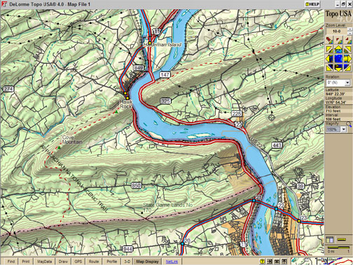
The figure, due to pixelization from JPEG compression, as well as my using a 150 percent magnification (useful when using in a car) means this doesn’t look as pretty as in real life, but here it is.
OK, What are the Drawbacks of
Topo USA
Topo
And, at equivalent zoom levels, Street Atlas USA Deluxe does show a just a bit more in the way of street and road names and numbers, and does highlight major secondary roads with a thicker line than you’ll see on Topo USA 4.0’s screen. But there is plenty of detail, the differences are relatively slight.
Topo
·
Many trails even in national parks
are named incorrectly, such as Dickey Ridge Trail not connecting to the
·
·
·
Dolly Sods Wilderness Area,
·
Otter Creek Wilderness Area,
·
Except for major long trails like
the
·
When you try to find the name of a
trail by right-clicking and picking “Info” you only get the name for a small
segment of a trail, not the entire length of the trail, so it’s very hard to
figure out which trails go where.
· Laurel Highlands Hiking Trail: shown more or less entire and labeled as such, although the trail location is wildly inaccurate (off by half a mile for long segments, check the LHHT near Ohiopyle for an example), and no shelters or side-trails shown.
· Black Forest Trail: instead of a 42-mile loop trail, I found a single 1-mile long dead-end trail
· Susquehannock Trail: instead of an 85-mile loop trail, I found nothing
·
Horseshoe Trail: instead of .a
140-mile horseback trail, I found a 1-mile side-trail to the
· Conestoga Trail: instead of a 65-mile-long trail, I found nothing.
· Mason-Dixon Trail: instead of a 200-mile-long trail, I found nothing
· Warrior Trail: instead of a 70-mile-long trail, I found nothing.
· Catawba Trail: instead of a 30-mile-long trail, I found nothing
· Youghiogheny River Trail: instead of a 43-mile-long trail, I found nothing.
· Rachel Carson Trail/Baker Trail: instead of 34 mile and 141-mile long trails, I found nothing.
· Mid-State Trail: instead of a 200-mile-long trail, I found nothing.
· Quehanna Trail: instead of a 75-mile loop trail, I found a 2-mile trail section that didn’t connect to another trail or even a road
·
Tuscarora
Trail: instead of a 250-mile-long trail in
· North Country National Scenic Trail (follows the Baker Trail in part): able to find manually, but not labeled on the map.
·
Tried the 50-mile Batona Trail in
Nonetheless,
Topo
What else
do you lose by using Topo
Looking
back, I’m not sure I’ve done this program justice. This is a program
that, while not perfect, is very likable. The maps are quite pleasant on the
eyes, easy to interpret, and for the most part quite accurate. Unless you
really need the restaurants or voice navigation, get Topo
Street Atlas Deluxe: a New Face
[This
review of SA Deluxe dates from October 2001 and is now slightly updated.] As
you can tell, I’m a fan of using a laptop with Street Atlas for real–time
in–vehicle navigation, and have been for some time, despite some early
problems. (“No, no, Street Atlas says we’re still on the right route!” “Well,
yes, but it also says
we haven’t moved for the past hour.” “Oh. Hmmm. I guess we DID miss the exit.”) I have tried a number of
alternatives to Street Atlas over the years, and although some had prettier
maps, none had the depth of detail or functionality that Street Atlas offers.
(But see above about Topo
Sidebar:
I do remember we installed one of Delorme’s competitors in the Jeep used by
emergency medicine residents to respond to critical prehospital emergencies
here in
The
development team at Delorme has been working on a new interface for quite a
while now, one that eschews many of the Microsoft Windows standards.
Instead, they have developed new user–interface design elements specifically
suited for Street Atlas and related programs. We’ve seen some of these elements
in Topo
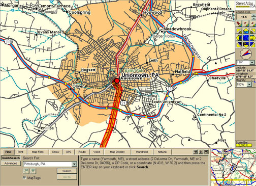
Instead of a toolbar and menu bar across the top, there are bars at the bottom and bar at the right side. The right–side bar contains controls and displays for zoom level, panning, map rotation (new with Street Atlas Deluxe: north up, southeast up, or any arbitrary degree up), the cursor’s latitude and longitude, the magnify level (not the same as zoom level), and a scale bar.
As with past versions, Street Atlas Deluxe allows
zooming from level 2 (shows all of
The bar at the bottom, however, contains the major elements of the new user interface. There are a series of tabs across this bar (Find, Print, Map Files, Draw, GPS, Route, Voice, Map Display, Handheld, Netlink). Each tab contains a set of functions accessed by a few buttons. I like the tabbed–notebook metaphor, and Delorme wisely avoided Microsoft’s confusing use of multiple ranks of tabs.
The figure, a relatively large JPEG, shows some of these features. Note in particular the map rotation, the 11–6 zoom level, the 150% magnification (the map looks prettier without magnification, but is easier to read with the magnification), and the easier–to–see route.
Major New Features
There are many, many new and improved features, only a few of which appear in this review or the help file documentation. Indeed, one of the joys of the new program is being able to find these new features (most are well–designed enough that they really require little if any documentation – good user interface design). A listing of what I see as the major new features, some of which were mentioned above, include:
· INCREMENTAL ZOOM: Ability to zoom in incremental zoom levels – no change in the geographic detail presented, but can see more or less area on screen.
· MAGNIFY: not the same as zoom, this magnifies everything, including the text labels – makes it much easier to see on a laptop screen in a vehicle.
· ROTATE: Ability to rotate the map view from north up to any other compass direction up.
· MOUSE ZOOM OUT: Ability to use the mouse to zoom OUT as well as in – click and drag left and up, which shows a little “staircase” that allows you to select the zoom–out level.
· AUTOMATIC RECALCULATION: Routes automatically calculate; as soon as you make a change, it redraws.
· MULTIPLE ROUTES: You can have multiple routes in memory at once – the active route shows a solid highlight (BTW, the highlight is MUCH easier to see in the Deluxe version) and calculated but non–active routes are shown by a dashed highlight. You may easily clear the display of any active route by right–clicking and then select “hide route” – not sure why you have to activate a calculated but non–active route to be able to then right–click and hide it, but it’s only another couple of clicks. You can also show or hide routes via their checkboxes in the Route tab, Directions button. Since the calculations are retained in memory, reactivating a route is nearly instantaneous. Routes are saved in files on disk, so once you get a route “wired” with all the shortcuts, you can easily save or share with others.
· IMPROVED GPS PLAYBACK: With the old version, you could import a GPS log file (*.gpl) and it would show as a highlighted line on the map. I found this particularly useful, for example, when someone led me in a caravan to a place I’d never been. If I ever need to go there again, I just retrieved the .gpl file, and followed the highlight on my map. With Street Atlas Deluxe, the .gpl files can be played back, and with much more control – the interface looks like a CD player, with fast–forward controls, pause, stop, and record buttons. Very nice. But if you want to import it simply as a line in Street Atlas Deluxe, you need to do it from Draw > File > Import.
·
BETTER SEARCHING: You can enter a
Route destination with minimal information (like
· ADD NEW ROADS: You can add new local roads, and they can be used for routing. However, you cannot add new “minor connectors” or state roads or interstates, nor can you upgrade your new road from local road to any other status, nor can you add trails.
· BETTER DISPLAY: The program now has a much more pleasing and easy–to–read map display – roads now curve more gently, antialiasing (smoothing the edges of text and small lines) is better, and there is a better display of unnamed streets at higher “mag” levels. When you have a color display capable of showing many colors, the program now takes advantage of this by using a more subtle but very–readable color palette.
·
INTEGRATED VOICE–RECOGNITION:
Previous versions of Street Atlas have been able to talk to you to give you
directions (and now Street Atlas Deluxe can say “turn left” or “turn right”
instead of giving a compass direction). To this, Street Atlas
· Extra Credit: Try holding the mouse cursor near the edge of the map and see what happens to the cursor. Try clicking when you see the cursor change and see what happens.
Upgrading from Previous Versions
You can import all of your Street Atlas 8.0 information, as follows:
·
To import your last saved route,
drag and drop your startup.sa8 (or any other .sa8 files you might have, usually
in C:\Program Files\Street Atlas
· More useful is to import all your Draw objects: from Street Atlas Deluxe, select the Draw > File > Import to import startup.sa8
·
You can use all your old GPS logs
as well: copy all your .gpl files, usually in
C:\Program Files\Street Atlas
What Do You Lose?
Do you lose anything in upgrading to the new interface version? Yes, a few things:
· Unlike Street Atlas 9.0 and previous versions, you lose the ability to hover the mouse button over a road or feature and see the name in the status line (though I hear this is coming back in the next version). You CAN right–click and select Info from the context–menu, but this is certainly not as easy as with the older versions of Street Atlas.
· Woodland overprint is gone. (But, to save space on the CD, it’s also missing from Street Atlas 9.0, which has the older interface but the same, latest data as Street Atlas Deluxe.)
·
Trails are gone. Even the northern
terminus of the world’s most famous trail, right in Delorme’s own
·
The Extractor is gone. With Street
Atlas Deluxe, if you want to run off your hard disk without the CD–ROM you must
install the whole CD to hard disk (561 MB) rather than extracting states or
counties. However, with the entire dataset (but with
limited POIs = Points of Interest), the load on your
hard disk for program and data is 646.5 megabytes – not bad considering Street
Atlas 8.0 with three states extracted onto my hard drive consumed 440.6
megabytes! Adding ALL of the POIs though, added only
167 megabytes. This seems like a lot until you realize this is the entire
What’s Not There Yet?
Yes,
Street Atlas Deluxe is a must–buy upgrade. And it’s a good, solid chunk of
software, even if you’ve never used it before. But there are some things
missing, many of which are also problems with Topo
No UTM
Unlike
Topo
No Upgradeable Roads
In both programs, one can still edit a road as far as one–ways, etc., as with previous versions, but there is still no way to upgrade or downgrade the quality of a road (e.g., change from “local road” to “minor connector” for a good shortcut so the program will preferentially route you this way). I’ve tried upgrading the speed for local roads, which helps a bit in better routing, but that’s a poor kludge: the program still makes me go a half–mile out of my way to use a “minor connector” instead of local roads. This ability to edit a road’s level is in the works for a future update, I hope.
Modal Interfaces Suck
With the
old Street Atlas
Yes, the tabbed bar at the bottom is a good user interface device. Nonetheless, it’s easy to get visually lost in the various panels within each tab – there’s no visual indication of “where you are” within the tab. If they used a little of the real estate in each tabbed pane for a few tabs at the left, or some other visual indication of where within the tab one “was,” it would get a lot higher marks from me. (But note that, on a professional basis, I regularly lecture on user interface design for emergency medicine software, so I’m probably more critical than most.) Overall, though, I’d give the interface a solid B–. (In my book, most software rates a D or an F, so I consider a B– pretty high praise.)
The principle is clear to any user interface designer: as much as possible, all major tasks (like PageUp/PageDown to zoom in or out) should be modeless, that is, they should work no matter which mode you’re in. Examples: assume you’ve just clicked on the “GPS Pan On” button, or clicked on something in one of the tabs and minimized the tabs. You then press the PageUp key to zoom out. What happens? Your PageUp key affects the “GPS Pan On” button, toggling it on and off – or, does something in the invisible tab at the bottom. (What does it do? No way of telling, as you can’t see it!)
“Use GPS as Route Start”
Since I first wrote this review back in October of 2001, I’ve used Street Atlas Deluxe a fair bit, and have found a few things more that are lacking, most particularly, a “use current GPS position as route start” function and the ability to use the keyboard for shortcuts to common functions. I’ve also talked with several people who really truly prefer the old interface.
Weblink Construction Info 2 Years Out of Date
I have also tried the Weblink option to download construction information. This is a bad joke. First, if you click on one of the construction signs on the map, it takes you to your web browser just to view three lines.
And I
live in Pittsburgh where I-279 going south from downtown Pittsburgh has been
closed for months and will be closed for more months, as well as major
construction along many area highways. But when I tried to download
construction information for this area, where’s the nearest construction flag
to
The Future of Street Atlas and Comparison with Other Programs
Street
Atlas has several competitors, and at one time or another, I’ve tried them, as
well as some similar programs for navigating in
But what about other types of map programs, even from Delorme? Well, first, let me discuss raster topo map programs. These programs display bitmaps of the USGS 7.5 minute topographic maps – basically they show pictures. These raster topo map programs have no “vector” information (mathematical descriptions of curves such as roads and rivers). Therefore, unlike Street Atlas, you can’t enter a street address and zipcode for start and finish and almost instantly see a route plotted. But if you need detailed topo maps of an area, for hiking, for search and rescue, or similar uses, such a program is ideal.
The
market leader is without question Maptech’s Terrain
Navigator. When Delorme came out with their 3D Topoquads,
Maptech suddenly and drastically reduced their price.
Terrain Navigator’s raster topo map visual quality is
superior to that of 3D Topoquads, and unlike 3D TopoQuads, the display still looks very good at multiple zoom levels. When you zoom out far enough in Terrain
Navigator, you see a display of the 1:100,000 USGS map for the area. As with
Street Atlas
Delorme’s 3D Topoquads is an interesting program, but quite different from Terrain Navigator. 3D TopoQuads will display all the 7.5’ topo maps for an area, in a seamless fashion. 3D TopoQuads provides elevation and location data, so you can search for particular places or view the topo map superimposed on a 3D reconstruction of the elevation. As you zoom back to look at the large picture, what you see is a vector display similar to Street Atlas USA, with added contours and woodland overprint, but without street names. It also shows the names of the 1:100,000 USGS maps and the quadrangles as you zoom out, but unlike Terrain Navigator, doesn’t actually show the real USGS 1:100,000 raster maps. It’s an interesting program, but with the poor visual display, and lack of 1:100,000 USGS raster maps, it falls significantly behind Terrain Navigator.
Installation Tips
Delorme suggests you use MSCONFIG to disable all startup options except for SYSTEM.INI (note that carefully) and reboot for a “clean install” prior to installing Street Atlas Deluxe. However, a lot of people use MSCONFIG to disable selected startup items – which is a good idea, as many programs install all sorts of junk that takes up memory and makes your system more likely to crash. however, if you have disabled only some startup items with MSCONFIG already, and then turn off and on the startup items with MSCONFIG, you will end up with all your startup items enabled.
Also,
Topo
There is
a simple solution to the Street Atlas Deluxe install problem, which is worth doing even if you don’t want to
install Street Atlas Deluxe: download the free program Startup
Cop from PC Magazine (www.pcmag.com), and use it to save a
backup profile of which startup items you want to disable. Then, when you’ve
installed Street Atlas
By the way, Startup Cop is much better than MSCONFIG for clearing out all those creepy little things that get installed in your System Tray and that you have no use for. Real Network’s StartCenter, which gets installed every time you use RealPlayer, is the particular subject of my wrath in this regard, but there are lots of other things worth disabling. On my system, I’ve disabled:
· ws_ftp’s ftp queue
· Scheduling Agent
· RealTray
· Creative Launcher
· LapLink Scheduler
· Creative AudioHQ
· Quicken Billminder
· WinFax Controller
Getting rid of some of these things will make your system more stable and make memory hog programs (like Street Atlas Deluxe, unfortunately) much less likely to crash the system.
Summary
So, what’s the bottom line?
Street
Atlas Deluxe is a much–changed but much–improved successor to Street Atlas
Or, if
you’d like much better maps with some trail information, and you’re willing to
give up restaurant locations and voice navigation, get Topo
Consider running it on a laptop in your vehicle on a Jotto desk – though it’ll take you some work to get it wired up, it’s worth it.
I hope you enjoy in-vehicle navigation with one of these programs as much as I do.
Disclaimer
Dr. Conover has no relationship, financial or otherwise, with Delorme, except as a paying and mostly satisfied customer, and getting occasional review copies of their software (which is more than he can say about his relationship with most software companies).