Clockwise
August 16, 2010
It is a mark of some distinction, in my small universe, to be the first person to circumnavigate Brunot Island in this and the last century. It is a mark I carry proudly. It places me at the forefront of sailors on the rivers around Pittsburgh. Perhaps that should be worded more carefully as "sailor," since there is only one of me routinely on the rivers.

Now that this mark has been acquired, to what should I aspire on my next voyage downstream? To be the sailor who circumnavigated the Brunot Island again seems less noteworthy.
On August 6, I had sailed Northward, downstream on the channel on the Island's Eastern shore and then returned on the channel on the Western shore. That is an anticlockwise circumnavigation. My new goal is immediate.
I shall be the first to circumnavigate Brunot Island clockwise!
It was simply a matter of waiting for the right wind and current. Over the weekend, I'd not sailed because of a prediction of storms with 65% certainty. They didn't come, but I was glad I'd waited. The weekend was oppressively hot.
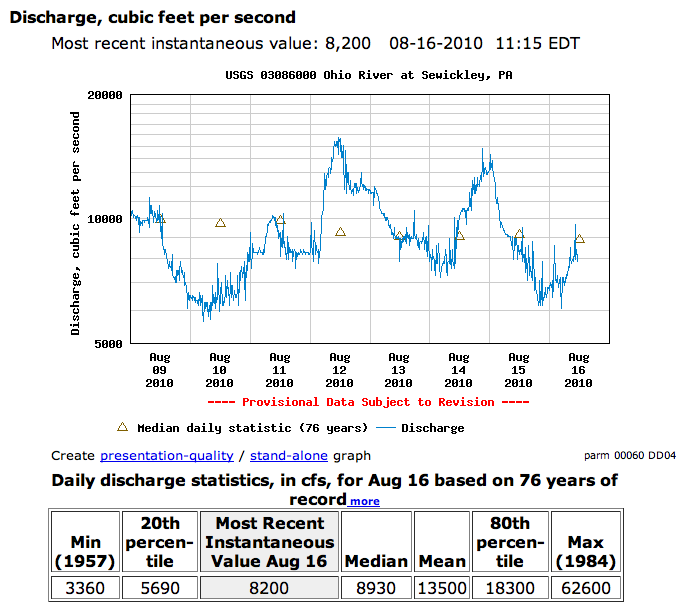
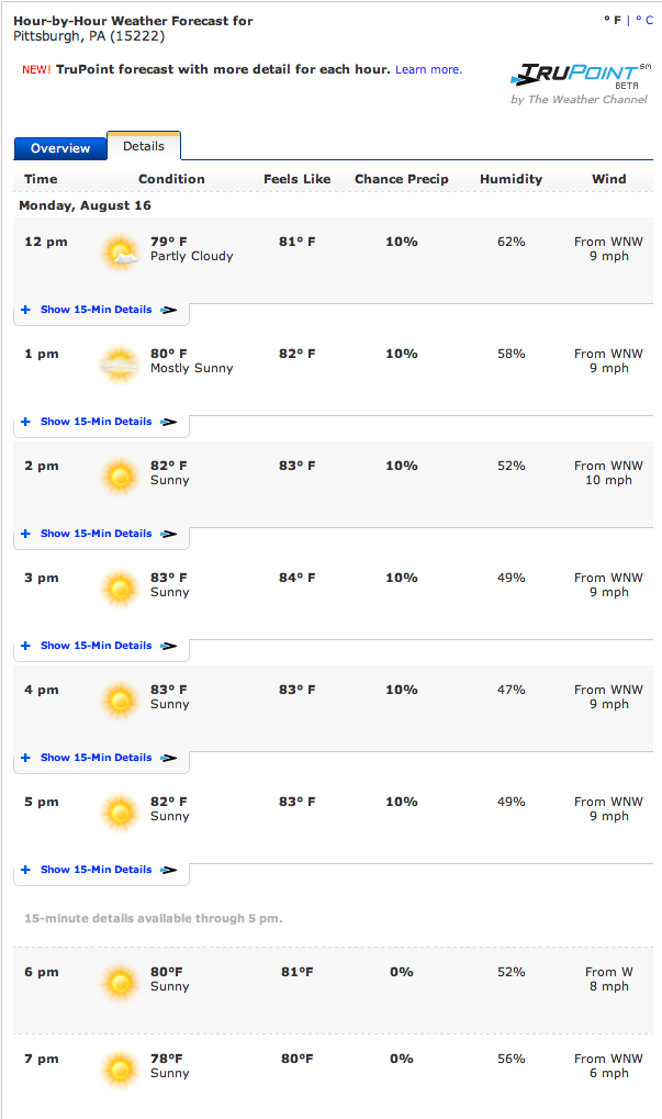
This Monday August 16 looked much more promising. It was a glorious day. The weather is warm, 82F. The sky is blue. There are gentle, white puffy clouds drifting by. The river currents are down. They are under 10,000 cubic feet per second on the Ohio River. Best of all, the afternoon forecast calls for West North West winds of 9-10 mph. Just perfect. They will blow, I hoped, down the Ohio, along the two channels around Brunot Island and make today's sail another easy circumnavigation.
On my bicycle ride over to the marina, everything looked perfect. There were winds in the 4-9 mph range at various points on the riverbanks, coming roughly from the West, and they seemed to be holding steadily at the Newport marina when I arrived.
The boat was soon rigged, slid down its ramp and in the water. Full of optimism, I set off into the river. My earlier experience sailing downstream had been of strong, consistent winds and there seemed no reason to expect anything different.
The winds care little for our expectations. As if to rebuke my hubris, they died to next to nothing before I could venture half way across the river. There I sat, feeling a little sheepish. I've learned that occasional calms are to be expected and that they don't last, mostly. So I waited. The wind came back and off I went.
This cycle of wind and calm continued for a while. There was usually enough wind to sail. Everyone now and again the wind would drop and I would slow or even stall. Then I would watch a gust move towards me across the glassy water and my boat would shoot off when it arrived.
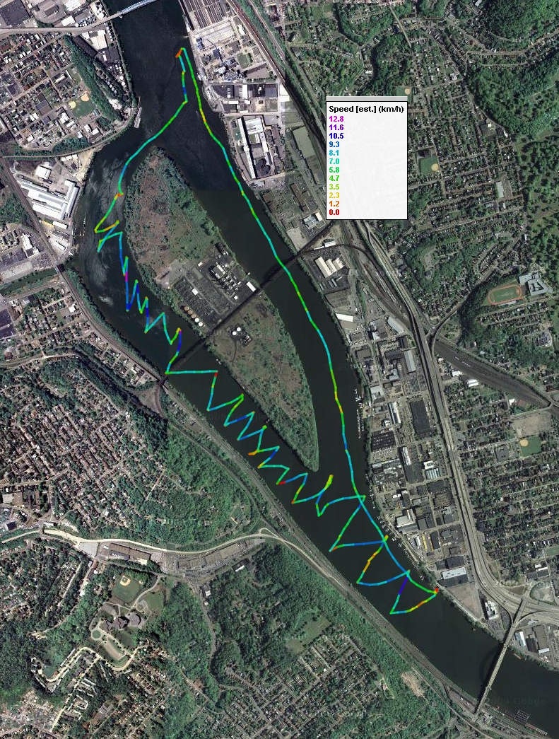
The gps track below tells the story most eloquently. The ups and downs can be confusing, so here's a key:
UP on the map = NORTH = DOWNSTREAM = UPWIND
DOWN on the map = SOUTH = UPSTREAM = DOWNWIND
I started at the bottom right and began the zig-zag of tacking up the Western channel. The track then continues to encircle Brunot Island. It is color coded for speed. The scale is in km/hour, so decode the deep blue 10 km/hour as 6 mph. The points to note are the specks of red (dead stop) and yellow and orange ones (1 or 2 mph). The dead stops appear as specks, but what the plot cannot show is how much time I was stalled in the one spot when my speed dropped to nothing.
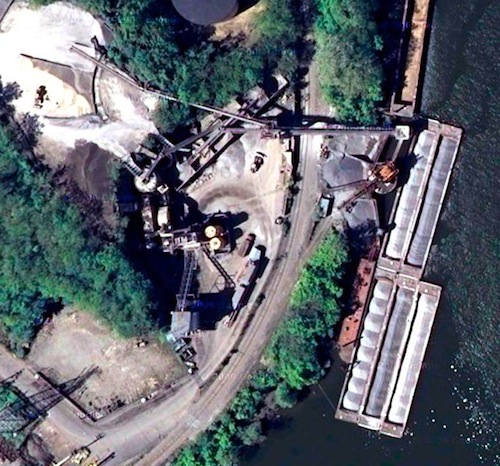
As I made my way towards the Western channel, a second problem became evident. The winds are blowing from the West North West. For most of the length of Brunot Island, there is a hill on the Western shore that will block the wind. There is a valley in the hill that aligns roughly with the upstream tip of Brunot Island. Then the hill ends somewhere in line with the downstream end of Brunot Island.
All this is easier to visualize in this figure. It shows a view looking exactly WNW, the direction from which the wind comes.
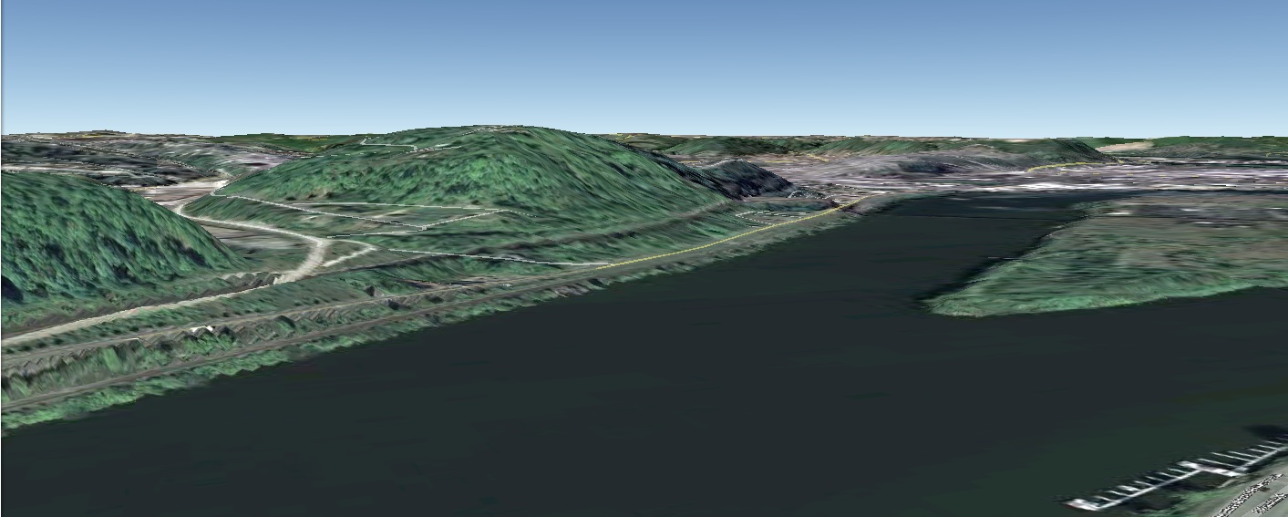
The Western channel is on the center-right, so the winds will be delivered to the channel by passing either way round the hill near the center-left of the image and then blowing towards our point of view. That produces uncertain winds all the way along the channel. The most confusing were at the upstream tip of Brunot Island (the lower tip in the map). I follow the wind when I sail on the river. My tortured wriggles near the upstream tip reflect my struggles to chase the wind and still make way into the channel.
My supposition is that wind from three places was meeting here: the valley, the Western channel and the Eastern channel. When they meet, all sorts of instabilities are likely to arise; and I'm not sure I had any chance of reading them.
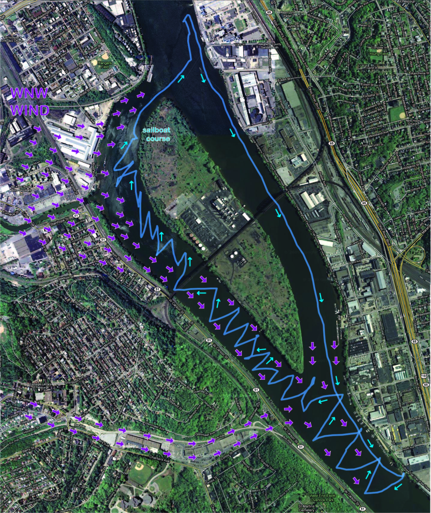
The winds were easier to read as I got further into the channel. They were blowing round the downstream end of the hill, across the river channel and then turning upstream. That wind pattern is revealed by the zig-zags of my tacking. In the middle of the channel, they are symmetrical, indicating that I was sailing into a headwind blowing upstream. Then, as I get near the downstream end of the channel, the zig-zags turn to to face the West. That is the direction from which the wind is now blowing.
Here's a figure that shows my best estimate of how the winds were being deflected:
Don't misunderstand. I'm not complaining. This was not trying sailing; it was interesting sailing. I've sailed the rivers enough now to recognize these sorts of wind effects. I was in a battle with the wind. But my foe was outmatched; it was dull-witted and predictable enough that I knew what it was likely to try and how to parry each assault when it came. Slowly and with increasing satisfaction, I made my way along the Western channel.
The tacks bring me within a few tens of feet of the Western shore. Major railway lines run along that shore; and freight trains lumber along them. There is something exciting about sailing in a river channel, flanked with greenery, close to the elements of nature; then a huge train lumbers past, so near that its noise blocks out the sound of the winds.
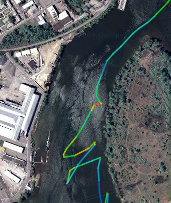
As I got closer to the end of the channel, I started to look for somewhere to beach. I'd like to take a few photos. After seeing nowhere really suitable, I furl the sail and let the sailboat drift. The hull swivels slowly, while I take few photos.
The pause is the little v shaped notch in the gps track. The speck of red is my boat with its sail furled and adrift.
Here's the view upstream, that is, looking into the channel through which I've just sailed.
You can see the trees and bushes that line the bank. All the way tacking up, I was worrying about getting too close to them. If I missed a tack and sailed into them, who knows how I'd get disentangled. They line a lee shore, that is, a shore towards which the wind blows. That is a legendary trap for sailors.
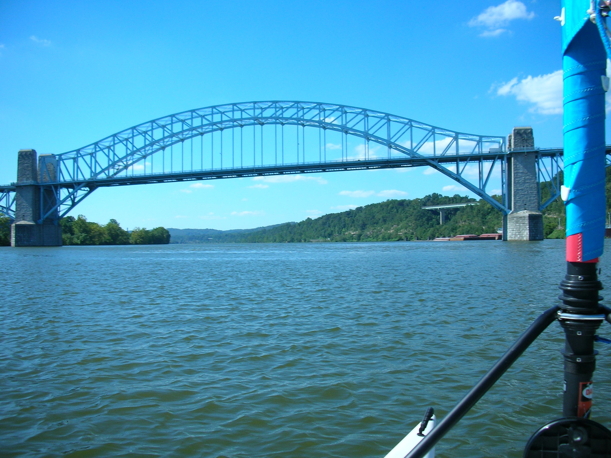
Here's view ahead to the downstream tip of Brunot Island. I'd been waiting to see it since that marks the point at which I can turn around and sail home. Until I see it, I don't know if the circumnavigation will succeed.
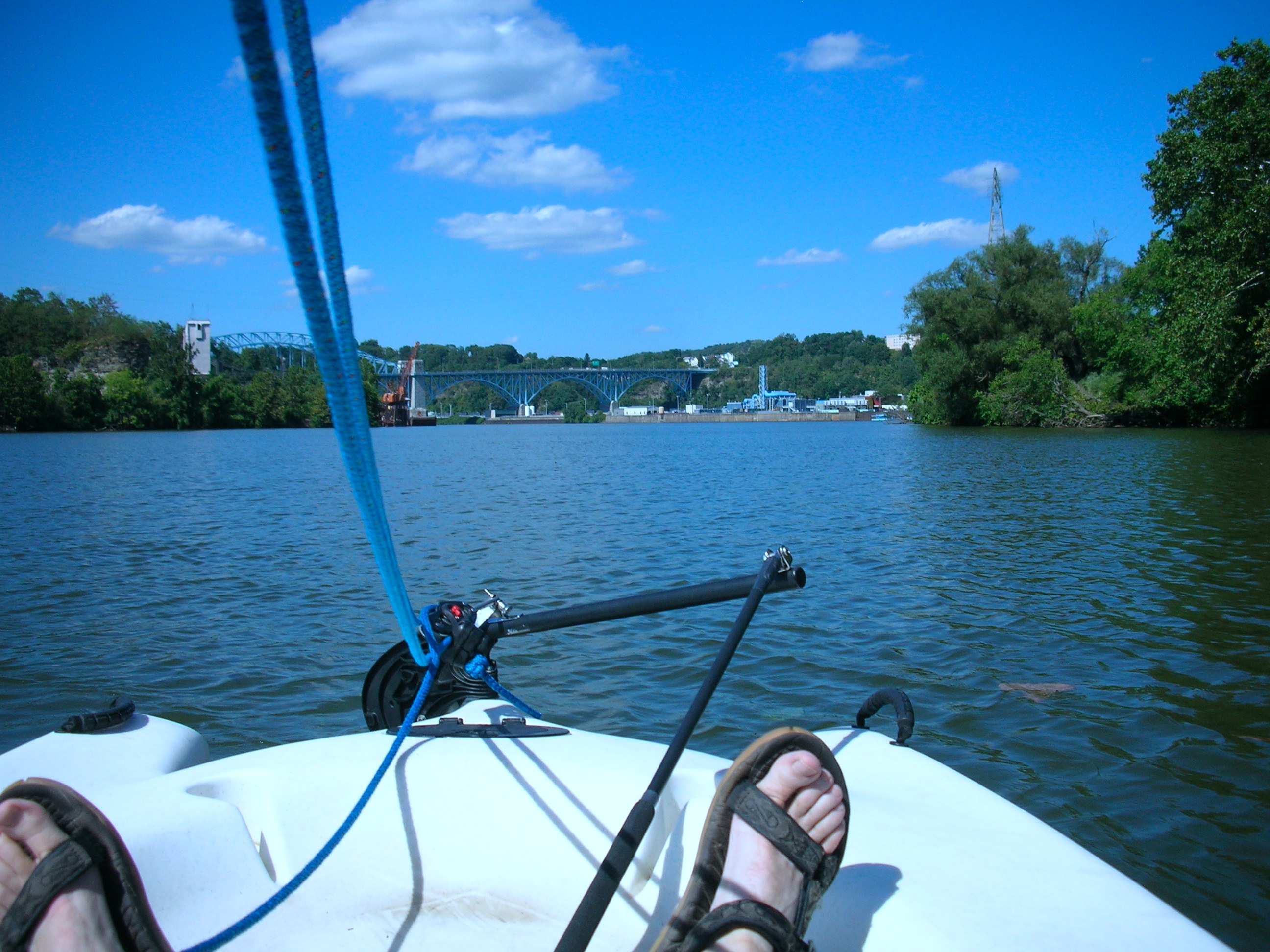
Looking ahead I can just see the Mc Kees Rocks Bridge and large plant of some sort.
The bright orange crane on the left is in use. It is scooping up something and dropping it, I think into barges. Whatever it is doing is punctuated by sudden loud metallic clanks that echo out over the water.
While I take these photos, the boat is being pressed by the breeze and is drifting closer to shore. My water bottle is looking for attention, but I dare not linger lest I end up on a weedy lee shore. I stow the camera, unfurl the sail and I am off.
Now the sailing is easy. As I approach the downstream tip of the Island, the wind blows from behind me. I run with it, rounding the downstream tip with ease.
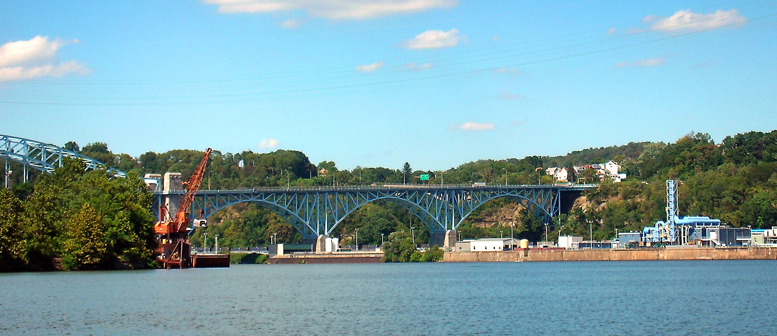
I was quite unprepared for what awaited me when that tip was passed. The McKees Rocks Bridge is a fluid blue arch that swung into view. From my low vantage point on the water, it soared skyward like a graceful steel animal that has settled just momentarily over the river. I had sailed in exactly these same waters ten days ago. How had I missed sensing its visual power? Then, I had been beset by strong winds and I resorted to a reefed sail. As I struggled with the wind, I would have sat with my back mostly to the bridge and my mind occupied by keeping the boat upright and moving.
This was too good an opportunity to miss, so I sailed further downstream towards the bridge. Then I furled the sail for more photos (and a drink of water--no time for pistachios).
It is hard to explain now the attraction I felt for the bridge. Perhaps it is because it is a small replica of the icon of my youth, the Sydney Harbor Bridge, whose monstrous arch found its way into the background of almost every memory. Here's a photo of it from a recent visit.
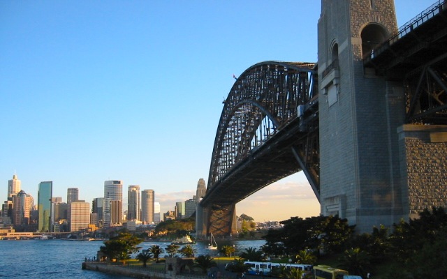
When it was taken, I'd just run across the bridge from the downtown (there called "the city"), visible on the left. It's a very big bridge.
Back on the Ohio River, I thought about sailing further downstream. The current was low and upstream winds would blow me home. What gave me pause was the water gushing into the river from an outlet on the Eastern shore.
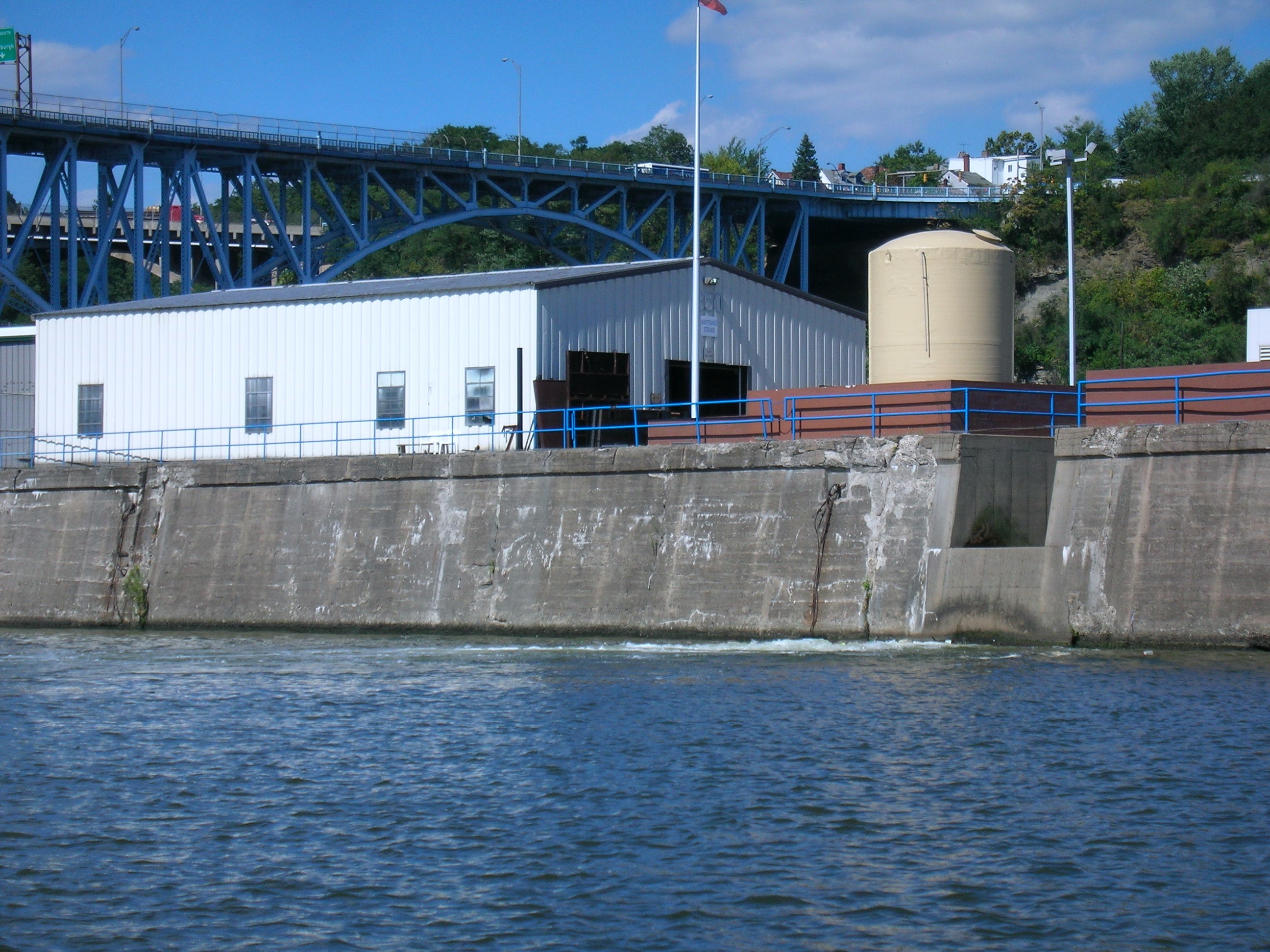
To proceed, I'd have to sail through it. Looking again at the plant, I realized it wasn't just any plant. The large letters said ALCOSAN and that meant Allegheny County Sanitation. It somehow seemed prudent not to inquire further but to sail home.
I unfurled the sail and turned my bows upstream. A gentle wind carried me along the river. When you move with the wind, it is hard to gauge exactly where it is coming from. I was estimating that I was on a sustained beam reach and then a broad reach. That is, the wind coming from the side and then diagonally from the rear. In all my sailing on the river, this was the first time I recall winds in a channel that weren't funneled directly down the channel. It was easy and restful. I might even say it was plain sailing.
The steel span halfway down Brunot Island is the Ohio Connecting Railroad Bridge. It is always a little thrill to sail under a bridge like that and watch its rusty span glide over my head. I run a little way further upstream when a large locomotive mounted the bridge. It was pulling a long train and working hard at it. So its engine was pounding loudly, building to a crescendo that just kept growing louder. Here again was the magnificent contrast of nature in the wind and water; and the raw power of industrial might.
The whole journey took a little over two hours. Allowing for stops, it took 95 minutes to tack downstream into the wind and only 30 minutes to run home. That ratio of 3 to 1 was larger than usual and reflected the difficult time I'd had gaining against the wind and perhaps also the speed of the run home.
Here are more versions of the GPS track.

John D. Norton
Back to main