Circumnavigating Brunot Island
August 6, 2010
Today was a great day sailing. It was even heroic, if one remembers the miniature scale of my voyages. But I'm getting ahead of myself. Let's start at the beginning.

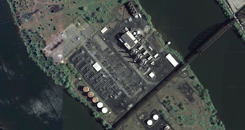
For a while, I've been imagining how much fun it would be to sail downstream from my base at the Newport Marina. The riverscape is quite different downstream. It's largely green with patches of industry. The first major feature is the green expanse of Brunot Island. It's narrow--only a thousand feet at its widest. But it is long, extending about a mile down the river. In the middle, hidden behind the bushes, is a small electrical power generating station. It has only oil and gas fired units, which are neater and cleaner than coal fired plants. The station is used only to meet peak loads; and it seems to be used rarely. A rusty iron railway trestle spans the Ohio River at the island at its midpoint.
That is downstream. From my earliest efforts, I have always used the same strategy on the rivers. Start downstream and sail upstream. It is my insurance policy if something goes awry with the wind. Without the wind I could rely on the current to wash me home.
That was a worthwhile insurance policy when the river currents are strong. In the event, I stay out of the rivers when the current is strong. A common flow on the Ohio River when I sail is 10,000 cubic feet per second. That corresponds to about 0.22 miles per hour. That current will require 5 hours to carry me the mile or so from the Point to the Newport Marina. So this insurance policy ought not to charge much of a premium on these days!
The conditions needed for sailing downstream are simple: not much current and a good wind blowing upstream against the current. I tried to sail downstream recently on July 24. I'd hoped that the roughly Westerly winds that day would suffice. Alas, there was enough of a Southerly component in the wind to have it blocked by the large hills on the Southern shore. What resulted was erratic wind too unreliable for me to want to depend upon in a new voyage into unknown waters.
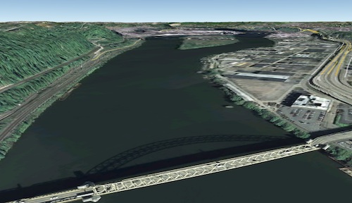
What I needed was Northwesterly winds. This image looks downstream in a Northwesterly direction from the West End Bridge, roughly my starting point.
It shows the massing of hills that deflect the wind on the Southern shore on the left. A Northwesterly wind would blow directly at us and there's nothing much to block it. That should mean winds steady in strength and direction.
I'd been watching the weather forecasts for a Northwesterly wind. This day it finally came. The forecast at noon (click) was calling for 8-9 mph winds from the West North West. That's close enough, I hoped. The temperatures were mild and the flows on the Ohio River, as reported around noon, were low. (click) It was just under 10,000 cubic feet per second, but rising.
On the ride over, I measured erratic winds in the 2-4 mph range. Conditions at the Newport Marina looked promising. There was a steady wind blowing upstream and little discernible current. However in the few minutes that it took to unload my gear and step the mast, the wind seemed to die.
The plan was to sail downstream into unknown waters, so I wanted to be sure that there was wind. That is one fewer uncertainty. There seemed to be some sort of weather change underway. The winds were blowing the big fluffy white cloud away. There was a big patch of blue sky and then purple gray storm clouds were massing in the North. There seemed no point in putting into a becalmed river, so I ended up waiting about 45 minutes for the new clouds to come overhead. They brought more wind and off I went.
The conditions were not just good, but great. The winds on the river were blowing steadily upstream at perhaps 10 mph. That is perfect. With this much wind, the little Bravo flies over the water, but is easy to handle. Quite soon I was at the upstream tip of Brunot Island.
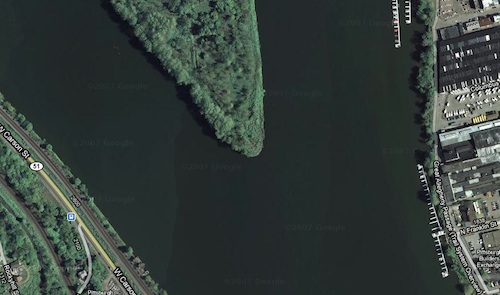
My original, cautious plan was just to sail that far and then reassess. The wind was good and steady and coming from the right direction, so there seemed no reason to stop. If ever there was a day to venture farther downstream, this was it.
All this is sailing into the wind, endlessly tacking to and fro. Back and forth I went; now passing the point of Brunot Island; now passing the little marinas that dot the shore. Soon I came to the railway trestle, which passed majestically over my head. The winds seemed to be getting stronger. My GPS told me I was hitting the Bravo's practical top speed of around 9-10 mph when the gusts came.
Finally, I had sailed nearly the full length of the Island. There is a rather nice dock at that point on the Northern shore of the Ohio. I'd been sailing for about 50 minutes, so it was a convenient place to stop.
I'd come a long way. My starting point was close to the West End Bridge and that bridge was just a distant arc barely visible under the rusty railway trestle.
A few people came up to chat. A sailboat on these rivers is, alas, quite a novelty. The downstream tip of Brunot Island was just slightly downstream of us. But it was hard to see in the tangle of greenery on the opposite shores. I needed to ask if that was its tip, just to be sure. The downstream tip is in the center of this photo and not much easier to discern if you are really there on the shore.
So far, these were perfect conditions and I'd enjoyed the sail immensely. I paused for my favorite sailing snack, pistachio nuts, eaten with my feet dangling over the water.
It was time to put back into the water. I'd spent perhaps 20 minutes on the dock, but in that time something had changed. I could see the wind now blowing more strongly over the water. Here and there little whitecaps were forming. That looked to me like 15 mph winds or more.
Once I put out into the river, it was clear that the winds has strengthened considerably. Having dealt with strong winds on my last sail, I knew what I had to do: reef the sail now. (Sailor's lore: if you are wondering whether you should be reefing the sail, it's already too late!) So I reefed the sail and battered my way into the wind for the remaining few hundred yards that would let me round the downstream tip of Brunot Island.
These were strong winds. Even with the sail reefed, I shot across the water. I glanced down at my GPS receiver and noted speeds momentarily over 9 mph.
After rounding that tip, I pointed the bows upstream. Now with the wind behind me, everything became a lot gentler. I was being blown with the wind, not fighting against it. A familiar calm settled on the deck as it surged through the waters. I made a steady 5-6 mph. These winds were kicking up some fairly impressive waves for a river, some perhaps 6". That is a lot when 6" is the height of the deck above the water. They were going my way, so I sailed along, surfing them.
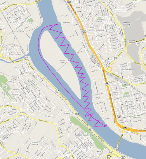
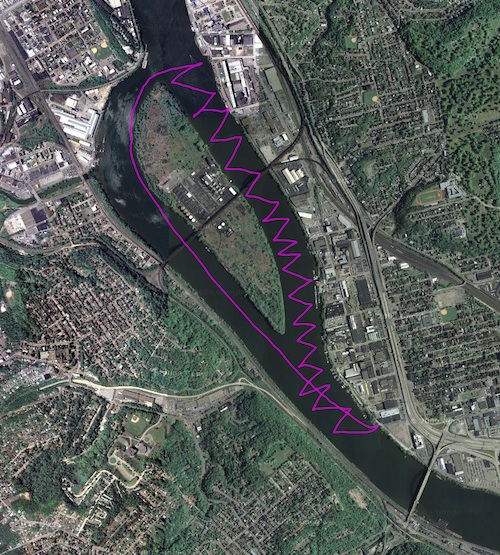
Here are the gps tracks, with my starting point at the Newport marina upstream in the bottom right hand corner:
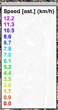
This one is color coded for speed.
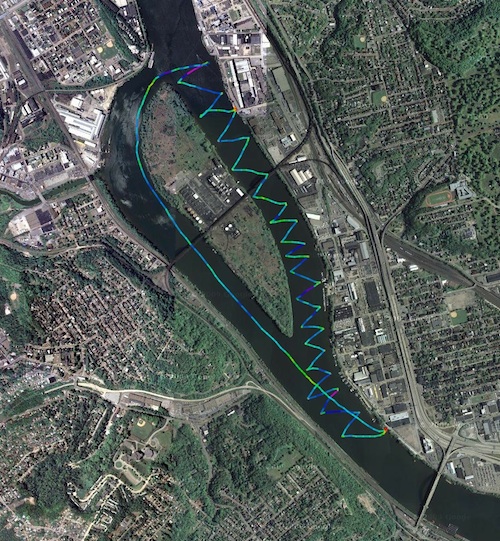
click for larger
The legend is in km/hr. The deep blue represents around 10 km/hr which is about 6 mph. So this shows that I maintained good speeds for most of the voyage.
During the time that I tacked downstream into the winds, I was not sure how far I would go. When I put back into the stronger winds, I was too preoccupied with them to think about anything else. But now finally, sailing upstream with the wind behind me--"running"--there was little to do but keep the bows pointed home.
The uncertainties of the voyage were over and I was starting to relax. It was then that I found myself smiling. Only last year, I had still wondered if I could sail on the rivers at all. Now here I was, sailing the wrong way on the river and going all the way round this island.
The river foreshores here are a wild and tangled mess of greenery. I'd guessed that no sailboat had slid past them for 150 years. They were the shores of a foreign land, whose waters I was sailing for the first time. My thoughts began to wander. I was a pioneer, an explorer. I was one with the great navigators of ages past. It is a heroic class. Ferdinand Magellan and Francis Drake circumnavigated the globe, passing imagined hazards and unimaginable dangers.
As I surfed along with the wind at my back and a rising wake behind me, past a rugged shore in unknown waters, I was the circumnavigator of Brunot Island. Perhaps it was a little foolish, but I was beaming.
All it took was a powerboat to roar past me at four times my speed to break the spell. Oh well. They might be fast, but I was having more fun. I could dream.
John D. Norton
Back to main
